Greenland 2000 Photos by Tony
Photo Albums - Bali | China | Thailand | Vietnam | Greenland | Newfoundland and Labrador | Greece and Turkey | Myanmar | Laos & Cambodia | India | 2007/08 Asia Trip |
|
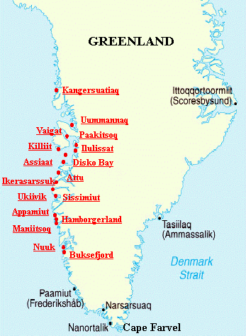
Click on the underlined places to enter the gallery These photos were taken during my sailing voyage from Sydney Nova Scotia to Greenland and back to Sydney between June and August 2000. I have tried to write the text to be of interest to both the cruising sailor and anyone thinking of visiting Greenland by more conventional means. You can see charts of my route and read Meriah's log by going to Voyage to Greenland Click here to see photos and description of Meriah our 32 ft sailboat. Read how we sent and received email via ham radio. Greenland For Everyone |
 |
Greenland is a challenging destination for the regular tourist. It's easy enough to get there by air of course but there are no roads between communities so travel within the country is by air or coastal boat.
If you like hiking then Greenland is a paradise. You can choose everything from short walks to challenging multi day hikes and the scenery is breathtaking. You are surrounded by rugged mountains, ice fields or icebergs - sometimes all three. The west coast is the main tourist area and contrary to popular belief it is not covered by snow and ice during the whole year although the interior ice cap is always present. We were there in July and the weather was 15C most days with blue skies, no rain and little wind - beautiful.
I am not trying to write a guide to Greenland. Click here for an excellent site for general Greenland travel information. Based on my experience visiting several communities by boat I would have to recommend Uummannaq for it's beauty and location, and Ilulissat for it's proximity to the spectacular ice fiord. Unfortunately I wasn't able to visit the south west coast near Nanortalik because of the ice conditions.
Greenland For The Cruising Sailor
The biggest challenge to sailing in Greenland is getting there. It's a long way from either Europe or North America. By the time you have planned how to get there and back while avoiding early season ice and late season storms you will be limited to a six or seven week cruising window in Greenland from late June to mid August. The east coast is not a practical destination until August because of ice however the west coast is a great cruising area and this is where most of the people live. There are several places to haul out in Greenland so if you are really determined then over wintering is a possible option.
Before I go any further I must mention the Royal Cruising Club cruising guide "Faroe, Iceland and Greenland" This excellent publication is available through nautical book suppliers or from Imray. The Imray web site has online updates which can be downloaded. The Greenland section is written by Willy Ker whom I have met cruising in both Labrador and Greenland. The latest update contains his changes based on 2000 information.
If you are serious about cruising to Greenland then you must get the RCC cruising guide so I will not attempt to duplicate the information here. If you are just interested in what is involved then I will answer some of the obvious questions.
Weather - there is a phenomenon called the "Greenland High" which settles over the west coast during July so you are likely to have light winds once you get to Greenland. We had light winds, bright sun, 15C temperatures and no rain for almost the whole of July, in fact I got a bit frustrated by the lack of wind. We had one really bad storm while at anchor. The weather starts to get more unsettled in August. The worst weather is likely to be crossing to and from Greenland but you will obviously be expecting that if you are considering crossing open ocean. Weather forecasts can be obtained in English from any Greenland coastal radio station but the information is very basic. You can also call a met forecaster using radio telephone for a more detailed forevast. I recommend having a weather fax so that you can read between the lines and make good decisions. Fog is always a potential problem in northern waters so it goes without saying that radar is essential. We had only two or three days of extensive fog and I am glad the fog didn't come down crossing the ice strewn Disko Bay.
Ice - the biggest problem is ice which sweeps down the east coast and partly up the west coast until quite late in the season, say late July. This prevents you making an early season landfall in the cruising area from the southern tip of Greenland (Cape Farvel) up the west coast to as far as Paamiut (Frederikshab) in a bad year. It also means you should keep well clear of Cape Farvel when heading for the west coast. This SW coast ice comes and goes depending on conditions so be very careful. Coming from Canada, we made landfall near the capital Nuuk (Godthab) which stays open all winter and we never did make it back south to the Qaqortoq area in the SW. If you are returning to Europe then you can visit this area on the way home. North of Nuuk, up to Upernavik, the ice should clear in plenty of time for a July cruising schedule.
Coming from Canada you have to be careful crossing "iceberg alley" off the coast of Newfoundland and Labrador but this applies all season. A bigger problem is to make sure that the winter ice pack has cleared off Labrador. We cut it very fine and spent a nervous night dodging the last of the growlers in late June. Crossing back to northern Labrador should be no problem in early August but you have to be careful of the "middle pack" in the Davis Strait which is slow to clear. We hoped to visit Baffin Island on the way back from Nuuk but there were still icebreakers operating in Frobisher Bay in late July so we diverted to northern Labrador.
Ice information is available on the internet at the NOAA Site This site provides historical information so you can do some planning based on previous years. You can also get charts from the Canadian Ice Service Ice charts are available via weather fax and from the Greenland Ice Patrol - see the RCC cruising guide for more information.
Charts - Danish charts for Greenland are very good. I got mine direct from Denmark from Kort & Matrikelstyrelsen they were very efficient. They will send you a catalogue chart first so that you can chose. Chart retailers can also get the same charts. The RCC cruising guide gives advice on which charts you really need for each location. I played it safe and got more harbour charts than recommended and I was glad I did. My crew obtained a copy of the British Admiralty Arctic Pilot and I bought the latest updates (the main volume was last published in the 70's) In fact we hardly used the Arctic Pilot and I don't think it is really necessary - also it's quite expensive - but you MUST get the RCC cruising guide.
General Cruising Conditions - I wouldn't recommend going to Greenland for your first cruise but generally speaking it is not as challenging as you might expect. The challenge is the same as crossing any ocean but once you are there it is no more difficult than many other remote cruising areas. For example, I would say it is much easier to cruise Greenland than say mid to northern Labrador. Perpetual daylight also makes trip planning very easy.
Here are some of the of the issues which effect
cruising.
Fuel
- available in most communities also good quality and cheap. I would advise carrying a lot
of spare fuel however because you may do a lot of motoring during the
"Greenland High"
Supplies
- the towns are nicely spread out on the west coast so you have more than enough
supply ports.
Boat repairs/supplies
- no yacht chandleries but there are lots of small power boats in Greenland so
some boating and electronic supplies are available. It is also a fishing
community so there are haul out and boat repair facilities.
Charts/cruising information
- excellent so you are never stuck to find somewhere to anchor or tie up.
Weather information
- quite good but I recommend a SSB radio and weather fax, see comments above.
Harbours -
quite a few spread along the coast. They are usually small and crowded but
everyone rafts
Anchoring conditions
- Some problems with kelp and rocky bottoms but generally very good. Many fiords
and bays are too deep to anchor easily but there are plenty of alternative
anchorages. I have a
35lb plough on a 32ft boat.
Navigation aides
- no buoys and the lights don't operate during the cruising season. There is a
system of day marks for the inside passages and quite a few racons. GPS works
fine but my Autohelm 3000 became very unreliable north of Disko Island.
Tides and currents
- tidal range up to about 8ft, currents can be quite strong in the inside
passages
Radio/emergency communications
- VHF coverage by Greenland coastal stations virtually everywhere on the west
coast but I would recommend a SSB radio as well.
| Home |
Contact Us |
| Voyage to Greenland
|